See Tropical Cyclone Nathan LIVE
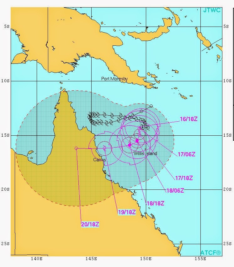
There is trouble brewing in the Coral Sea for the Queensland coast of Australia. Cyclone Nathan will intensfy into a category 3 cyclone and hit the area just north of Cairns on March 20, 2015 (Brisbane Time).
Nathan has come and kissed the coast of Queensland earlier, than drawn away back to the Coral Sea. It has been aimlessly wandering about in the last few days.
It presently lies about 450 kilometers east-north-east of Cairns in the Coral Sea. In the coming days it will intensify gradually and move towards the Queensland coast.
By early March 19, 2015 it will have become a 150 kph howling monster. It will intensify further to winds of 160 kph and then hit the Queensland coast just north of Cairns on Thursday afternoon (GMT), early hours of Friday (Brisbane Time).
At landfall wind speeds may reach 175 kph with gusts up to 200 kph.
Read More On Tropical Cyclone Nathan
 |
| SATELLITE IMAGE OF CYCLONE NATHAN TAKEN AT 0330 HRS GMT MARCH 17, 2015. IT IS GOING TO INTENSIFY AND HIT THE QUEENSLAND COAST NEAR CAIRNS ON MARCH 20 AS A CATEGORY 3 CYCLONE. |
 |
| TRACK FORECAST FOR CYCLONE NATHAN MARCH 2015 |


No comments:
Post a Comment