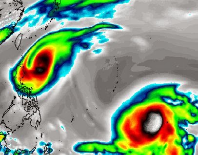
Typhoon Dolphin (Egay) is going to turn into a very powerful storm in a few days. Guam is going to be affected. Latest forecasts say Philippines will be spared as Dolphin will swing away north before landfall. This is expected to happen on May 16, 2015. Anything can happen in five days. Philippines should keep its fingers crossed.
++++++++++++++++++++++++++++++++++++++++
FLASH: The JTWC in its latest track and intensity forecast says Typhoon Noul is likely to pass northern tip of Luzon on May 10 with speeds of 120 knots. There are still 5 days to go and the path of Noul is slowly curving towards Philippines. And with each successive forecast the intensity of typhoon Noul is increasing. Bad news for the country.
Update - May 5, 2015
-----------------------------------
 |
| THIS FORECAST MAP SHOWS AN INFRA-RED SATELLITE IMAGE OF THE WESTERN PACIFIC ON MAY 9, 2015. TYPHOON NOUL IS LEAVING PHILIPPINES WATERS WHILE TYPHOON DOLPHIN IS GROWING STRONGER |
Let us talk about Noul first. The storm is about 100 miles east of Yap Island and moving WNW. It is strengthening all the time. Our very conservative estimates say the sustained winds in the storm are 75 kph. In the next four days it will ponderously move in the same (WNW) direction. By May 10 it will be a few hundred kilometers away from the Luzon coast. By then it will have intensified into a 140 kph storm.
According to the latest forecasts by the JTWC issued at 0900 hours GMT today the typhoon will be throwing out sustained winds of 115 knots by May 9. A super typhoon has winds of 130 knots. Inching close.
Our prediction is typhoon Noul will not make landfall into Luzon, Philippines but veer away sharply and move north on May 10-11. Even then the flail-clouds of the powerful storm will bring heavy rains to northern Philippines on these days.
Predicting even further, we believe typhoon will not hit Taiwan nor the Japanese mainland. We expect the storm will swing north-east and miss Japan. But this we cannot say with surety at this stage.
Now coming to typhoon Dolphin. It is presently an innocuous low pressure area bobbing in the Pacific Ocean. On May 7, 2015, it will start intensifying and turn into typhoon Dolphin. Dolphin will be even more powerful than Noul. But fortunately for Philippines it is expected to swing northwards on May 10 and miss hitting the country.
Our predictions at this stage are based on what reliable global forecast models say. Things can change as tropical cyclones are inherently fickle by nature. We shall keep you informed with latest updates and monitor any changes in the path of the two typhoons.


No comments:
Post a Comment